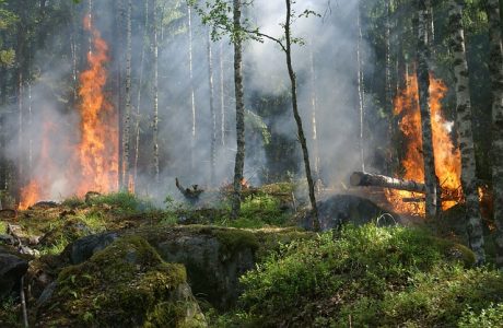
Utilities need incisive, fast, data-driven methods for dealing with natural disasters like wildfires – both before and after disaster strikes.
Hurricanes, extensive flooding, record-high temperatures, record-setting droughts, and wildfires are redefining both how power companies are managing major weather events and even redefining major weather event thresholds. For instance, while the number of wildfires may not be alarmingly different, the size of the fires and total acreage burned has grown in addition to the devastating threat to public safety. Storms as powerful as Hurricane Harvey have gone from 100-year occurrences to now emerging every 16 years.
See also: Can AI Improve Disaster Response?
California utility companies have responded to this trend with the Public Safety Power Shutoff (PSPS) program, a relatively new initiative that makes determinations about when and where to cut the electricity to a particular area based on environmental factors like temperature, rainfall and predicted wind speed. Cutting the power to an area at risk of a wildfire ensures that the continuing flow of electricity doesn’t start or contribute to a disaster until after the threat has passed. Although the very premise of PSPS goes against the central mission of power companies (i.e., utilities are meant to provide reliable electricity to customers, and this program aims to cut that power when necessary) it has become a necessary tradeoff in order for utilities to adapt to a rapidly changing environment and mitigate the impacts of devastating wildfires. It’s for that reason that we’ll see not only the number of PSPS responses but the number of utility companies embracing similar preventative measures, continue to grow.
But PSPS is also not the end-all, be-all solution to both mitigating wildfire risks and managing the aftermath. Other, more tech-driven solutions, like conducting environmental inspections via automated aerial systems like drones, provide new ways for expanding the scope of what utility companies can do to curtail the threat of major weather events to their customers.
The Limits of PSPS
In the event of a potential wildfire, California utilities will execute PSPS to shut down the power in a perceived threat area. That threat assessment is determined by environmental conditions, weather forecasting, satellite data, etc. to assess the likelihood of a wildfire and where and when it could potentially occur. But, a complication of this tradeoff is that the PSPS program itself can also create safety risks:
- Power is a commodity that emergency systems, first responders, and the public all rely on. Shutting it off, even with the best intentions and in the most necessary circumstances, can still produce safety concerns.
- Additionally, the environmental concerns that triggered the need for PSPS can inadvertently lead to vegetation and other debris damaging utility equipment and potentially remaining in contact with electrical infrastructure. When re-energized, this contact could possibly trigger a wildfire – exactly what PSPS was intended to mitigate in the first place.
That second concern also dovetails with a larger issue with PSPS: it’s limited as a purely preventative measure. While that’s important, it naturally cannot address what needs to happen after the fire has been put out or the storm has passed. Because once the threat is over, the utility company needs to then re-energize the lines to restore power. Before doing so, they must also make sure nothing has happened to the integrity of their lines or other field infrastructure – for instance, that trees haven’t fallen onto wires or poles haven’t failed in a manner that resulted in downed power lines. The operators at the power companies are blind to these conditions on their own, though. They need a field presence to determine when and where it’s safe to restore power to consumers.
That knowledge gap is currently filled by deploying line workers in the air and during the daytime only. There is an opportunity to improve this by:
- Automating aerial inspections using various sensors to capture environmental conditions and make assessments fully (initially with manned flights but ultimately unmanned ones); and
- Developing infrared sensors and capabilities to conduct automated assessments beyond daylight hours.
Utilities need incisive, fast, data-driven methods for dealing with natural disasters like wildfires and how they affect their customers’ power needs – both before and after disaster strikes. A strategy that can both improve the effectiveness of PSPS programs and reduce the need for PSPS altogether. Automated aerial inspections provide that new avenue for power companies to more quickly and nimbly assess post-disaster damage, expedite aftermath management, restore power to customers, and prevent the inadvertent triggering of new wildfires.
Filling the Gap with Automated Aerial Inspections
Utility companies currently conduct field inspections with either line workers or helicopters to assess environmental conditions for when and where to re-energize power lines. This is, however, a fraught process for a number of reasons:
- It can be slow and time-consuming, depending on the extent of the PSPS program and the lines de-energized.
- It’s limited to the number of qualified line workers and aircraft available.
- Even with qualified line workers, the process is not foolproof. It’s a find-the-needle-in-the-haystack situation where missing just one needle can result in another wildfire.
- The ability to make these visual assessments is dependent on weather conditions. If it’s too windy, it may be dangerous to fly. Additionally, flight inspections are constrained by daylight availability, so there is a limited window of hours to work within.
Conducting these field inspections via drones with high-resolution sensors addresses these limitations, providing clearer and more comprehensive inspection data for making critical PSPS decisions, like assessing environmental risks and pinpointing when and where to cut (or restore) power, all in faster and safer ways.
Drones can be deployed to monitor fire- and storm-ravaged areas for line damage, providing more up-close and objective analyses than what is visible from the human eye, and utilizes machine learning algorithms to more quickly identify potential issues. These aerial inspections make life easier for field workers, too, allowing them to review assets remotely with high-resolution sensors that can be deployed beyond just daylight hours and still gather critical inspection information.
It’s a win-win situation all around: the power companies are armed with faster and more accurate insights about their post-storm field assets to make quicker determinations for restoring power; field workers can get that work done faster, and without needing to enter hazardous areas themselves, with the drones; and the consumers get their service restored even faster.
Ultimately, as we face an uncertain landscape where wildfire risks will only get worse, not better, in the near future, aerial inspection technology provides power companies with a new edge to stay ahead of the curve. The inspection data provided by automated aerial systems complements PSPS programs, empowering utilities to quickly, accurately and safely pinpoint trouble spots and wildfire risks, mitigate these potential dangers, manage the aftermath and get the lights turned back on for everyone.