Powerline inspection is a non-negotiable anywhere in the world: it simply must be done. However, the reasons why it is essential, the consequences of doing it badly, and therefore the most appropriate approaches all vary widely between different markets.
For example, while in California a major driver is wildfire prevention and mitigation, such concerns are almost non-existent in a place like Germany. Here, the biggest drivers for powerline inspection are maintaining customer service levels and minimizing repair and maintenance expenses, and the most important factors in a powerline inspection regime are thus cost and efficiency. This is a mature, advanced economy where there are extensive rules and regulations to follow, and where both cost (of labor, for example) and expectations are high.
So, a challenge for a company with ambitions to provide a turnkey solution for advanced powerline inspection worldwide: how can that one key unlock different, diverse markets?
Our answer to that at Sharper Shape is: with flexibility and an intelligent approach to partnership. Recently, this allowed us to conduct two successful pilot projects for German utilities, working with UAV-based LiDAR (Light Detection and Ranging) specialist, Orthodrone GmbH.
The deal with drones
In 2020, Sharper Shape engaged with two German utilities interested in taking a smarter approach to powerline inspection. Traditionally, this task involves teams of inspectors ‘walking the line’ to manually inspect for signs of wear, damage or potential risks to the powerlines from external factors such as nearby vegetation (no one wants to lose power because a tree branch has fallen on the line in high winds, for example). This approach is extremely time- and resource-intensive for high-voltage powerlines networks that can stretch to tens of thousands of kilometers.
A faster approach is to augment ground-crews with aerial inspection, either by helicopter or fixed-wing aircraft. Not only does this allow for inspectors to make a visual inspection of a far greater area in a shorter time, it allows for the collection of other forms of data from above, such as hyperspectral imagery, or LiDAR data.
By adding this data, aerial inspection becomes a far more attractive proposition than simply an accelerated alternative to ground inspection. This data can be cross-examined so that utilities can better analyze, understand, predict, and plan powerline management issues, using cutting-edge data science. For example, our Sharper CORE software uses LiDAR data to map vegetation and other objects near powerlines, and then applies machine learning techniques to identify those objects, even down to the species of tree. Utilities therefore gain an understanding of which points in their network are at risk from close or fast-growing species, allowing them to plan accordingly.
However, using manned aircraft incurs great deal of expense and is not always viable in a cost-conscious market with slim margins for utilities. Fortunately, recent years have demonstrated the ability of unmanned aerial vehicles – or drones – to act as an alternative.
Pilot project pilots needed
The utilities both wanted to work with Sharper Shape to trial powerline inspection and LiDAR collection via drone to gauge the suitability of the approach. Sharper Shape itself has experienced drone pilots and the ability to collect such data, however, it became clear that we were not best placed to execute that part of the project on a short timescale. Instead, we opted to partner with a German company experienced in the field – Orthodrone.
Why was that the better option? As Juri Klusak, CEO of Orthodrone explains: “In Germany, permit procedures change from state to state regarding the operation of drones. In the state of Schleswig-Holstein where we are based, you obtain a permit and can then fly as often as you like. In other states, you must obtain separate permits ahead of each flight and supply details of the job to the local authorities. We are often approached by police during jobs and you have to have everything in order – it’s rightly taken very seriously.”
As a company headquartered in Germany, Orthodrone already had the experience in place to navigate the local regulatory environment. As a partner, they also offered excellent technology and skilled pilots.
Klusak elaborates: “We use heavy-duty hybrid drones, meaning that they use a combustion engine to generate power for the electric motors. This greatly extends the range and lifting power of the drone, which is essential if you’re looking to mount heavy (and expensive) LiDAR sensors and cover large distances, as you need to in the case of powerlines. We also have very experienced personnel who have planned and flown high-risk missions, from supporting Arctic Icebreakers to research expeditions in Antarctica. Germany may not be as extreme as that, but there are definite challenges. For example, for one of these projects we had to take off and land in a vineyard with an extremely steep slope and limited viewing angles. That’s hard. We also had to fly within very narrow corridors with paths hemmed in by parallel lines. At one point we had to cross a river carrying commercial traffic – that requires an experienced position spotter and good team communication to ensure you don’t fly over boats. It all takes skill. Finally, bear in mind that for a LiDAR mission you cannot just stop and hover the drone in a difficult moment – you need to do all this while maintaining a minimum speed of 4m/s or risk compromising data accuracy.”
Mission successful
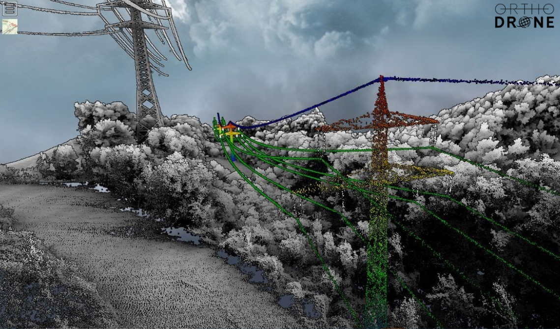
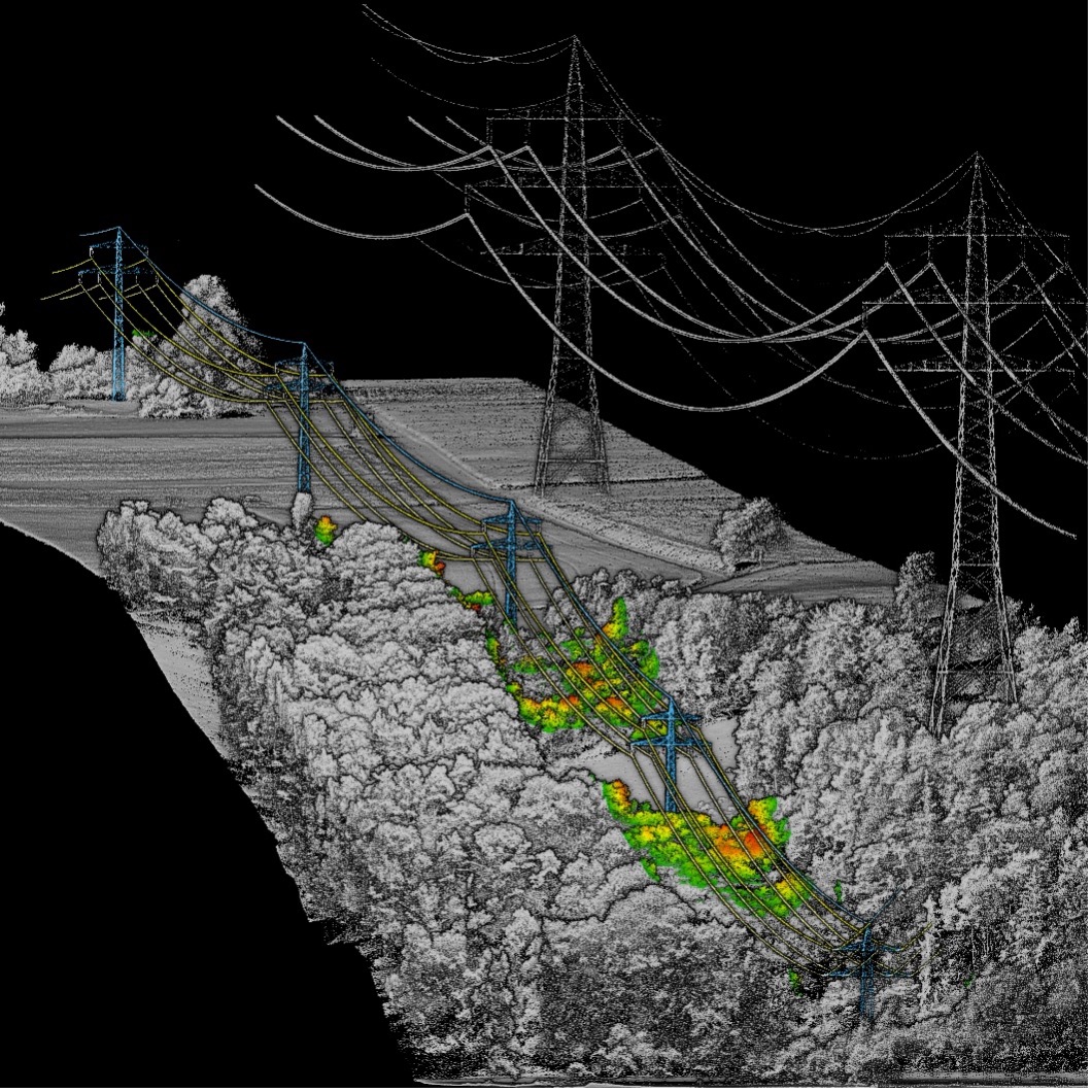
Both utilities declared the project successful (you can read more about one of the projects here). They were able to examine LiDAR images – images they had never seen before (see below) accurate to 2-3cm – and with the Sharper CORE system they were able to use this data to get extremely accurate descriptive and predictive analytics.
These projects opened the utilities’ eyes to what is possible. The logical next step would be to undertake extended trials over a larger area. At that point, the utility begins to get a real model – a digital twin – of their network and the power of the Sharper Shape software comes to the fore, helping them to better plan, predict problems and allocate resources and save money versus other inspection methods.
Orthodrone was a fantastic partner to work with, and these projects validate taking a flexible approach. In some cases, the most effective option will be for us to pilot the drones ourselves. In others, it will be to work with partners – be they start-ups or major players. Ultimately, we best serve utilities by not limiting options and assessing on a case-by-case basis.
For clients, it remains a turnkey service – but this model means that Sharper Shape’s is a skeleton key – one that can unlock many different markets, whether operating solo or with a high-caliber partner such as Orthodrone.

A LiDAR image taken from one of the projects, courtesy of Orthodrone GmbH. High-resolution LiDAR point cloud with a visualisation of masts, insulators, and powerlines as well as distance of surrounding vegetation to powerlines

