In a time of aging infrastructure and growing climate threats, electric utilities are under pressure to modernize faster and smarter. The solution? Data—and not just any data, but AI-powered insights from LiDAR. With the ability to transform raw point clouds into strategic intelligence, AI-driven LiDAR classification is fast becoming an essential tool for utilities looking to improve safety, reliability, and efficiency.
What Is LiDAR—and Why Is Classification Critical?
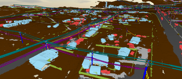
LiDAR (Light Detection and Ranging) captures billions of 3D data points that map every detail of utility infrastructure and surrounding environments. From power lines to substations to nearby vegetation, LiDAR delivers unmatched visibility. But those raw points alone don’t tell a story—they need classification.
Classification transforms raw data into actionable insights by labeling each point (e.g., tree, conductor, pole, ground). This enables electric utilities to:
- Spot and address vegetation risks before they trigger outages or fires
- Monitor pole lean, wire sag, and asset health
- Ensure regulatory compliance with precise clearance data
- Plan for storm response, grid upgrades, and emergency management
Without accurate classification, LiDAR is just noise. With it, utilities gain clarity and control.
The Manual Bottleneck—and Why It No Longer Works
Traditional LiDAR workflows rely on manual annotation and rule-based algorithms—time-consuming processes that can’t keep up with today’s scale. Modern utility scans can span hundreds of square miles and billions of points, requiring months of processing time and often risky overseas outsourcing.
These methods are reaching their limit in terms of speed, cost, and scalability.
AI LiDAR Classification: The Utility Game-Changer
AI, especially deep learning, is reshaping how LiDAR data is processed. Instead of relying on static rules, AI models learn from labeled datasets to automatically identify even subtle or overlapping features—like power lines obscured by trees.
With AI, utilities can:
- Classify large datasets in hours instead of weeks
- Handle complex, cluttered environments with higher accuracy
- Automate QA/QC to flag anomalies and ensure data reliability
- Minimize manual input while increasing precision
The result? Actionable, high-confidence insights delivered in days—not months.
What to Look for in a Classification Tool
Choosing the right tool is about more than speed. Utilities should prioritize:
- AI-first workflows for maximum efficiency
- Advanced feature extraction (e.g., buildings, conductors, ground segmentation)
- Scalable architecture for handling billions of points
- Interactive 3D visualization for intuitive data interpretation
- Hybrid workflows that combine automation with expert review where needed
The best tools don’t just classify data—they transform it into decision-ready intelligence.
What’s Next: AI + LiDAR + Real-Time Utility Ops
The future is even smarter. Upcoming advances in predictive modeling will allow utilities to forecast vegetation growth, detect asset fatigue, and assess fire risk—before problems occur. Edge computing will enable real-time LiDAR classification onboard drones or vehicles. And system integrations will feed classified data directly into GIS and maintenance platforms, streamlining response and planning.
As sensor costs drop and AI matures, this technology becomes accessible to utilities of all sizes—ushering in a new era of smarter, more resilient grid management.
Conclusion: Ready for the Power Play?
AI-powered LiDAR classification isn’t just a technical upgrade—it’s a strategic leap forward. For utilities facing rising demands and limited resources, it enables faster, smarter, and safer infrastructure decisions.
At Sharper Shape, we help utilities turn point clouds into power plays—with AI-driven classification that delivers accuracy, scale, and impact. Because the grid of the future doesn’t wait—and neither should your data.